C
Crocky
Guest
Last Sunday we got hit with a 5.8mag earthquake nearly 5 yrs to the day after the deadly earthquake that killed 185 people on 22 Feb 2011.
This got me to thinking whats happened here and I thought I might share some info over the next wee while photos thoughts of what the city and I have been through.
The first big quake was 4 September 2010 at 4.35am a 7.2mag
The earthquake's epicentre was 40 kilometres (25 mi) west of Christchurch,[15] near the town of Darfield. The hypocentre was at a shallow[15] depth of 10 km
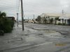
The main shock on 4 September caused widespread damage and several power outages, in Christchurch damage was estimated at $ 3.5billion big for us, we were lucky everybody was in bed otherwise it could have been a lot worse
This link takes you to interactive quake map showing whats happened from the start to the end
click on the links to the top left and let it play shows where frequency of quakes aftershocks etc including depths (all very shallow)
http://www.christchurchquakemap.co.nz
have a look a play through really interesting
Cheers Crocky
This got me to thinking whats happened here and I thought I might share some info over the next wee while photos thoughts of what the city and I have been through.
The first big quake was 4 September 2010 at 4.35am a 7.2mag
The earthquake's epicentre was 40 kilometres (25 mi) west of Christchurch,[15] near the town of Darfield. The hypocentre was at a shallow[15] depth of 10 km
The main shock on 4 September caused widespread damage and several power outages, in Christchurch damage was estimated at $ 3.5billion big for us, we were lucky everybody was in bed otherwise it could have been a lot worse
This link takes you to interactive quake map showing whats happened from the start to the end
click on the links to the top left and let it play shows where frequency of quakes aftershocks etc including depths (all very shallow)
http://www.christchurchquakemap.co.nz
have a look a play through really interesting
Cheers Crocky


")