


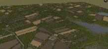
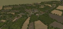
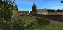
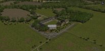
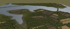
The Amfreville Overhaul project has now been renamed Amfreville and la Fiere. I have completed everything except flavour objects west of the Merderet River and have expanded the map to the eastern shore to recreate the la Fiere bridge and le Manoir. This will allow me to recreate the battles to capture and defend that location as well as the 325th GIR and 82nd Abn's assaults on the causeway and follow-up attacks. Should be able to cover all the actions from June 6th, 1944 through June 10th. A few screen grabs included below. The first three are looking west. The pic with the church is the village of Amfreville looking north. The farm complex is the Chateau d'Amfreville which the 82nd airborne referred to as the 'grey castle'. The last pick is looking at the eastern shore under construction. The map is now almost 3.4 west to east x 2.6 km north to south.
Attachments

Last edited: