Welcome to The Few Good Men

Thanks for visiting our club and having a look around, there is a lot to see. Why not consider becoming a member?

Operation Windsor 2.0 (Now with trailer)

Ithikial

FGM 2ND IN COMMAND
Staff member
Joined
Nov 28, 2011
Messages
4,709
Reaction score
2,678
Age
39
Location
Perth, Australia
Operation Windsor has always had a special place in my war gaming heart. Insane amounts of destruction compressed into a small geographic area. The taking the village of Carpiquet and the adjacent airfield from the fanatic (no other way to describe their defense) 12th SS. The the makeshift defense by the Canadians against an attack in the middle of the night.

Pretty sure there's a forum topic post floating around here somewhere showing my first attempts to make a Carpiquet map, however it became apparent the approach was all wrong. The map was to large, the bulk of the scenario (playing as the Canadians) would be getting across the open ground, and the airfield buildings became far to difficult to model correctly. To top it all off this plan wasn't even taking into account the southern attack.

However I've been reading Hubert Meyer's "The 12th SS: The History of the Hitler Youth Panzer Division" and got some ideas going about how to break it down into possibly a four scenario campaign.

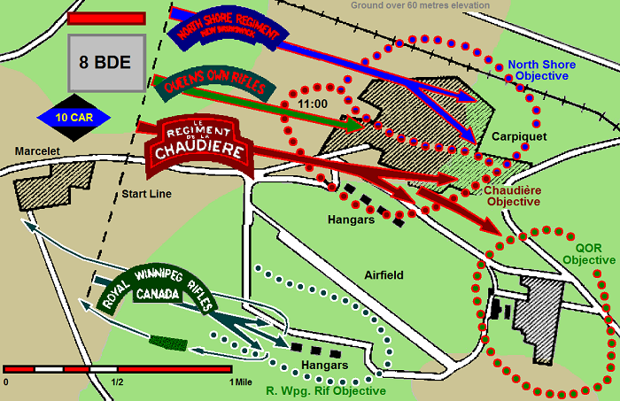
Firstly this is a good map showing how the Operation took place...


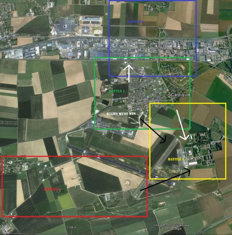
And here's my idea of breaking it down into manageable chunks...


July 4th - 5th
Designed to be Played as Canadians... [] equals allied links to follow on battles. () equals Axis links to follow on battles.
Battle 1: The Set Piece -> Continue a massive barrage on an already heavily damaged town. Two weakened battalions - reflecting heavy losses in the hour and half long approach under German arty fire - enter the urban area over to and try to clear it out from the fanatic defenders with armored support. [Possible shared Air Support with Battle 2] [North Shore Regiment Survivors move to Battle 4] (Any German Survivors move to Battle 3) Allies Must Win.

Battle 2: The Southern Foley -> The Royal Winnipeg Rifles confusion plagued attack on the southern defenses and hangers. German armored counterattack. (Any German Survivors move to Battle 3).

Battle 3: The Command Buildings -> Historically the Queens Own Rifles were beaten back and never took the buildings as German Panthers arrived on the scene. Would be the difference between a Total and Regular Campaign Victory. Beat history.

Battle 4: The Counter Attack -> Fresh SS forces launch an armored counter attack at night from the north in an attempt to distract battered Canadians so they could withdraw their forces from the command buildings. Gameplay terms desperate night defence.

Still being mulled over in my head but with all this research and maps sitting here on my computer it would go to waste if I didn't do anything with it. The smaller version of this would just be worried about Battle 1, but that may be too easy for the allies if they can be more risky with their troops not having to worry about future engagements. Since this all occurs within the span of just under 24 hours replenishment of losses would be very limited.

Thoughts?
 
Creating a 'monster map' of Carpiquet north to Franqueville which will be cut up for battles #1 and #4 and will crossover to extent. No pics yet still a long way off.

Possible Individual Scenario Names (Not 100% on 3 & 4, number 2 was probably shouted quite a lot by the Canadian soldiers on the ground during the battle).
#1 - Blackader's Regret
#2 - Where are the F****** tanks?
#3 - Just one more field <----Also thinking now this is only played if Battle 2 is won by the Canadians. Otherwise skip straight to 4. Will be the most 'what if' of the scenarios.
#4 - Midnight Surprise

Okay one thing I like to do is write up a first run draft briefing. This outlines in words what I'm trying to cover and puts some geographic boundaries on the scenario/operation. Will probably change dramatically before first testing (still miles off) but this is the designed as the start of operation level briefing.

Let us know what you think and provide criticism. Feel free to ask any queries about how I plan to model some of these instances outlined below. (Will be possible spoilers). Here we go....


Brigadier K.G. Blackader, CO 8th Canadian Infantry, 3rd Canadian Infantry Division, 0450 July 4th 1944, Marcelet

Situation

Operation Epsom has officially ended and although gains were made, there was no decisive breakthrough as first hoped. Monty has authorised Operation Windsor, a smaller brigade sized action to capture the village of Carpiquet and the adjacent airfield. The capture of these objectives will allow further advances towards the River Orne on the west side of Caen and as a possible springboard for a larger Operation currently being prepared. The ground to the south of Carpiquet is unique as being the highest ground this side of the city – it is likely being used by Jerry to observe any Allied movements around or towards the city itself.


Mission

Attack, clear and secure the following objectives:

- The village of Carpiquet

- The northern airfield hangers and buildings

- The eastern airfield buildings

- The southern airfield hangers


The attack will take place in two phases, the first commencing at 0700 hours, the second at 1100. The bulk of the operational ground forces will be dedicated to the push on the north side of the airfield to take the village and northern part of the airfield, while a smaller force attacks the airfield’s southern defences. Phase two will include follow on forces to assault operational buildings on the far eastern side of the airfield we suspect is being used for German command and control in the area. Once all objectives are secure, 8th Canadian Infantry Brigade prepares defences and hold for likely counter attacks.


Friendly Forces

Forces from the 3rd Canadian Infantry Division has been chosen as the primary ground force for this operation. As major operations have been focused on either flank of the divisions position over the past three weeks, it has given the force a chance to rest and refit following some disastrous engagements at the start of the campaign. Division has decided that the 8th Canadian Infantry Brigade - reinforced with additional support - will conduct the assault on both the airfield and village. 8th Brigade is current spread out to the west of Carpiquet and the airfield, with the brigade CP set up in the village of Marcelet.


The three infantry battalions of the 8th Brigade will be the primary force of northern approach. They are competently led and were involved heavily in the early fighting in June. At nearly full strength and well equipped they are a sizeable force going into this operation.


The North Shore Regiment – New Brunswick and Le Regiment de la Chaudiere will conduct the main assault into Carpiquet and the north side of the airfield. The Queens Own Rifles will be held in reserve and pass through the cleared village four hours later to continue the advance by assaulting the suspected command buildings on the eastern edge of the airfield.


A and B Squadrons (Sherman/Firefly) from the Fort Garry Horse, 10th Armoured Regiment, 2nd Armoured Brigade will follow the leading battalions to provide close tank support. Two M10 AT Destroyers have also been brought forward for anti-armour support. Some heavy howitzer armed Churchills, from the British 79th Armoured Division are also on call to help bust the concrete bunkers.


The southern approach will be attacked by the Royal Winnipeg Rifles, nominally with the 7th Canadian infantry Brigade, they have been assigned to the 8th Brigade for the operation. C Squadron (Sherman/Firefly) from the Fort Garry Horse will provide tank support for this attack if required. Note that despite the rest and refit the Royal Winnipeg Rifles are still understrength from actions over June 6th – 7th.


Support

Operation Windsor is the only major action planned for the day across the Caen sector and as such considerable assets have been assigned support the attack. From 0500 hours 21 artillery regiments from across the Corps will conduct a Great War style creeping barrage ahead of the infantry advance, while also maintaining a continuous rate of fire onto the village and airfield. HMS Rodney’s 16 inch guns will also be fired directly onto the village just prior to the infantry assault. RAF Hawker Typhoons are also set to be on standby after dawn.


Enemy Forces and Intelligence

The village and airfield have been heavily reinforced and extensively fortified with well-prepared positions. Concrete bunkers and trench systems are in place around the airfield. Given the surrounding terrain this area is likely considered a key point in the Germans defensive strategy for the Caen sector.


Corps and Division agree that a direct assault over the open ground of the airfield itself would be unwise as the open ground would be a killing field for our armour from likely 88 positions. In addition it is suspected that with the ample time the Germans have had to prepare, an in depth minefield is probably also in place before the bunker and trench system.


We have observed over the past three weeks movements of troops, equipment and vehicles (including tanks) passing through the area from Caen heading west to counter Operation Epsom. Maps and aerial surveillance suggests there are some good roads between the airfield, Caen and the Orne River allowing the Germans to bring in reinforcements quickly if required. The best we can tell is that the Germans occupying the operation area are from the 12th SS Panzer Division ‘Hitlerjugend,’ the same force that decimated elements of the Canadian 3rd Division on June 7th just north of here. Despite their youth, expect a well-trained, disciplined outfit that is competently led. There are also reports coming down directly from Monty that an additional SS Panzerkorps is heading towards the Normandy theatre. We don’t know where and when they will deploy but we must finish this Operation and be in a good defensive position before these fresh forces arrive.


Plan

Hopefully the artillery barrage will destroy or dislodge the majority of Germans from their positions before your main force gets close. Once you Battalion CO’s get close they will be required to call down the final artillery missions and support from the navy. Once that is complete, get your infantry into the cover of the buildings and clear out the objective areas. The concurrent attacks on the north and south side of the airfield should be enough to keep the Germans off balance and divide their forces.


There are some supporting actions close by to support Windsor (Scenario Design: Not incorporated), the Cameron Highlanders of Ottawa (MG Company) will move in and protect cover your north flank, so you’ll get warning if the Germans decide to reinforce from that direction. The British 43rd Wessex Division is also launching a diversionary action into the village of Verson to the south to draw away German forces from your advance.


Good luck Brigadier, give them hell.
 
Picked up a subscription to the above website (been meaning to for a while) and it became clear looking at the detailed pics that the modern Googlemap for Carpiquet simply doesn't offer even half of a what the village looked like in 1944.

Bad news - Mapping takes a step backwards so another delay to getting some pics here.
Good news - Less buildings to map!
 
@Ithikial how much was the subscription.

18 pounds for a 12 month subscription including your sales tax... VAT is it? (Or there abouts).

The pics are generally pretty good, you can make out individual houses etc or at the least work out what where urban sprawl hadn't occurred in 1944. Probably not a good option for overlay in the scenario editor as you can't download the highest resolution as one big BMP or JPEG file. You have to zoom in and then dload individual sections - more a hassle than anything else. If you want the highest resolution photo you have to pay for a copy for each frame. Most of the photos I've looked at in Normandy are dated June 6th so far.

If you're after a specific area let me know and I'll get you some pics.
 
Most of my CM time has been thrown at mapping the 1st of the 'Master Maps.' This one is of Carpiquet itself, the Northern Hangers and Franqueville where the 1st SS launched their counter attack from o the 5th of July. This map will be sliced up and used for missions #1 and #4 above, possibly also a battle #5 if I chose to break up the German counter attacks matching the historical circumstance. One just after midnight and one around dawn beaten off by artillery and air support.

Anyway still a way to go but roads and fields are largely mapped out more in accordance with the aerial photos that Googlemaps which is completely inaccurate for this area in 1944.

Overview from the highest elevation in the editor. Still some missing at the bottom and I'll need to extend a but further west than this to give the Canadians more room to deploy for mission #1.


From the Southwest of the map (airfield). Big buildings are place holders for the hangers. Centre left is where one of the bunker complexest at the north west side of the airfield is located. Overlooking the Canadian deployment area.


Railway looking south at the Canadian approach/deployment.


Beyond the first line of German defence where the village itself will be. Church in as fixed reference point. This photo is from the west looking east.


Franqueville in the north overlooking Carpiquet down the escarpment to the south. Northern portion of the airfield is 'over the horizon.'


This last shot is the 1st SS Division's counter attacks starting positions. Further research shows they had armoured support with a good contingent of infantry, especially for the dawn attack when Panthers were employed. The chance to doing a night armoured (which was more of a probe the way I read it) attack could be a lot of fun. :D But that's still a long way off.

Thoughts?
 
Still mapping. Lots of work done to the north of this pic for the later battles of the planned series. As a final thing for tonight changed all the urban areas with the 'Hard' ground tile. Gives an indication of how much is still to go with the buildings, and they were quite densely populated even in 1944. Also allows me to get my bearings and scale right looking at print outs of 1944 aerial photos.

Image is roughly the area for mission 1 (minus the northern hangers just to the south of this pic and still a bit more to the west, which is just fields).


A good sign for me as the map maker is for the first time I can see the 'flow of the battle' from my work - based off all the reading I've done surrounding the engagements of July 4 and 5, 1944. Even a 'had a moment' while tiling near one of the intersection where I could pin point where a company XO bought it from a German mortar round.
 
Any updates on this one? I'll be happy to playtest it once it's ready :).

Spent the last little bit of editor time finalising the Three Patrol Action scenario following the feedback. Changes made and Bootie has kindly helping with some of the art work.

The 1st Master Map is coming along nicely but Carpiquet village is taking some time There is still the second master map to the south and east of the airfield that has to be done next but that should be easier as it's mostly fields. Will probably release this map when done to interested parties to fight over QB style and find any niggling map issues. Still going to be a long process to do right. :(

Very cool. I think your TPA scenario will turn out great with the tweaks you're doing. Sounds like the campaign is moving along as well. Yeah, I find that I can't mod or make maps for large amounts of time. I much prefer the little here, little there method. Keeps it more enjoyable since I work on it when I want to work on it. Looking forward to this campaign, though!
 
Very cool. I think your TPA scenario will turn out great with the tweaks you're doing. Sounds like the campaign is moving along as well. Yeah, I find that I can't mod or make maps for large amounts of time. I much prefer the little here, little there method. Keeps it more enjoyable since I work on it when I want to work on it. Looking forward to this campaign, though!

Cheers Rambler. If I could replace my day job I'd edit during the day and play games at night. :p Also helps when there's a little history that makes the engagement interesting. Still got to one day go back and recreate the Joe's Bridge Scenario. (Now that MG is out and that engagement wasn't covered means there's a gap to fill). Also thinking for CMFI the New Zealand engagements around Orsogna in December '43.
 
Yeah have thought about it as well and trialled it out in a few places, can't remember if I've kept it though. I think for the Carpiquet map I'm using tiles of dirt instead of roads for the paths leading to the sites of German fortifications etc. Using the tile option is probably better when showing a makeshift road or an organic path that has appears through ongoing use rather than planned design.

The same trick also works visually with gravel roads going to a gravel dirt tile. The only thing I'm wary of is if the game itself treats vehicle movement on a gravel/dirt roads differently to a gravel/dirt tile. ie. Higher chance to bog on a gravel tile compared to a gravel road.
 
Back
Top